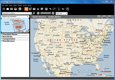
Microsoft Streets & Trips
~ the obit ~
streets & trips was us-coded at the licensing layer. the box covered the us and canada, with mexico thrown in. a separate european version called microsoft autoroute included turkey, but the cultural product, the road-trip-planning cd-rom that lived next to encarta on every american family pc, was something i only really encountered as a screenshot in tech magazines and in other people's vacation stories. it was the kind of software that assumed you owned a car and a paper map and just wanted them to talk to each other.
microsoft sold the line from 1988 to late 2014. the early years were rebrands of an existing nextbase product. by the late nineties microsoft had absorbed it into its consumer-software arm next to encarta and money, and was shipping annual releases with state-line accuracy and points-of-interest data. there was also an optional usb gps receiver in the box. the 2013 release was the last one. microsoft killed the line in 2014 and shut off the online support in july 2015.
the death was clean for an obvious reason. google maps had become free in your browser and the iphone had a real navigation app by 2009. built-in car gps was moving from luxury option to standard equipment in most new cars. nobody needed a $40 cd-rom that you had to upgrade every year to get the new roads.
~ the rap sheet ~
| Born | 1988 as Automap Road Atlas, later rebranded Streets & Trips |
|---|---|
| Peak | annual cd-rom releases through the 2000s, sold at every office-supply store |
| Killed | discontinued late 2014, online support ended july 14, 2015 |
| Lifespan | 26 years |
| Made by | Microsoft (originally NextBase Autoroute) |
| Killed by | google maps and the iphone moving navigation into the phone |
~ the long tail ~
the people who actually loved streets & trips were a specific kind of user. rv owners planning long road trips, plus retirees who wanted to print a turn-by-turn itinerary on paper before getting in the car. for them the disconnect-from-the-internet model was a feature, not a limitation, and there are forum threads from 2015 onward about how to get the last version running on windows 10 because nothing has really replaced it for that workflow.
the closest thing on the modern market is the offline mode in google maps, which works but does not do trip planning the same way. furkot and roadtrippers exist as web tools but neither owns the category. streets & trips quietly held a niche the entire time it was alive, and the niche has been carved into smaller pieces in the years since.
~ the day it died ~
microsoft's announcement was a single sentence on a support page in late 2014. no farewell post and no migration tool. no recommended replacement either. the lack of a successor was the giveaway. microsoft had already conceded the entire consumer-mapping space to google and apple, and there was no point pretending streets & trips was still a strategic product.
~ leave a rose ~
an anonymous tribute. one rose per visitor per day.
@}-->-- ... roses left here
~ leave a wreath ~
a rose fades by morning. a wreath stays on this grave for good, with your name on it.
from $1, paid once through stripe. it keeps the graveyard running: the hosting and the nightly digging. adopt it and the headstone reads "maintained in memory by" you. the groundskeeper plants new wreaths at the next tending, usually within a day.
» one email a week: new graves and the anniversaries of the dead. subscribe
other software: Microsoft 3D Viewer, Taligent, Urchin, BackType
also died in 2010-2014: LightScribe, Flexplay (EZ-D), Urchin
~ leave a note ~
visitors before you have left these graveside notes. anonymous welcome.